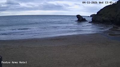
Webcam Llangrannog en direct, prévisions surf et température de l'eau
Mis à jour 4 nov., 12:00 UTC
Conditions actuelles
En ce moment à Llangrannog : 16 nds de ENE, rafales à 23, vagues de 0.7 m, eau à 14 °C — petites vagues, idéal pour débuter.
Prévisions à 7 jours
Heures affichées en heure locale · Vent, vagues et température de l'eau : données ouvertes ECMWF (CC BY 4.0) · Marées : EOT20, DGFI-TUM (CC BY 4.0)
🔒 Les jours 4 à 7 sont Pro — La formule gratuite montre les 3 premiers jours. Passez Pro pour voir toute la semaine.
🔓 Pro — 19 € / an
Les prévisions complètes à 7 jours sur chaque spot, un pass annuel à prix fixe.
Passer ProPrévisions surf
| mer. 4 | jeu. 5 | ven. 6 | ||||||||||||||||||
|---|---|---|---|---|---|---|---|---|---|---|---|---|---|---|---|---|---|---|---|---|
| 12 h | 15 h | 18 h | 21 h | 00 h | 03 h | 06 h | 09 h | 12 h | 15 h | 18 h | 21 h | 00 h | 03 h | 06 h | 09 h | 12 h | 15 h | 18 h | 21 h | |
| Surf (est.) | 0.5 | 0.6 | 0.5 | 0.5 | 0.5 | 0.5 | 0.5 | 0.4 | 0.4 | 0.4 | 0.4 | 0.3 | 0.3 | 0.3 | 0.3 | 0.2 | 0.3 | 0.3 | 0.2 | 0.2 |
| Houle principale | 0.214s↑ | 0.213s↑ | 0.213s↑ | 0.213s↑ | 0.213s↑ | 0.212s↑ | 0.212s↑ | 0.212s↑ | 0.211s↑ | 0.211s↑ | 0.111s↑ | 0.111s↑ | 0.111s↑ | 0.110s↑ | 0.26s↑ | 0.15s↑ | 0.110s↑ | 0.110s↑ | 0.110s↑ | 0.110s↑ |
| Houle secondaire | 0.110s↑ | 0.110s↑ | 0.110s↑ | 0.110s↑ | 0.110s↑ | 0.110s↑ | ||||||||||||||
| Mer du vent | 0.63s↑ | 0.64s↑ | 0.64s↑ | 0.64s↑ | 0.64s↑ | 0.53s↑ | 0.53s↑ | 0.53s↑ | 0.53s↑ | 0.53s↑ | 0.43s↑ | 0.33s↑ | 0.43s↑ | 0.33s↑ | 0.11s↑ | 0.11s↑ | 0.12s↑ | 0.12s↑ | 0.12s↑ | 0.11s↑ |
| Vagues | 0.7 | 0.7 | 0.6 | 0.7 | 0.6 | 0.7 | 0.6 | 0.6 | 0.6 | 0.6 | 0.4 | 0.4 | 0.3 | 0.3 | 0.3 | 0.3 | 0.2 | 0.2 | 0.2 | 0.2 |
| Période | 4s | 4s | 4s | 4s | 3s | 4s | 3s | 3s | 3s | 3s | 3s | 4s | 3s | 4s | 3s | 7s | 10s | 10s | 10s | 10s |
| Énergie | 1 | 1 | 1 | 1 | 1 | 1 | 1 | 1 | 1 | 1 | 0 | 0 | 0 | 0 | 0 | 0 | 0 | 0 | 0 | 0 |
| Houle longue | 0.1 | 0.1 | 0.1 | 0.1 | 0.1 | 0.1 | 0.1 | 0.1 | 0.1 | 0.1 | 0.1 | 0.1 | 0.1 | 0.1 | 0.1 | 0.1 | 0.0 | 0.0 | 0.0 | 0.0 |
La hauteur de surf est estimée à partir de la houle principale pour une plage qui lui fait face ; les récifs, les bancs de sable et la marée la modifient. Énergie en kW par mètre de côte. Houle longue : vagues de 12 s et plus. Houle : NOAA WAVEWATCH III · ECMWF
Marées (48 h à venir)
Infos du spot
- Commune: Llangrannog, Ceredigion
- Plan d’eau: Mer
- Sports: Surf
- Meilleures directions de vent: ESESESSE
Llangrannog is a small village tucked into a steep valley on the Ceredigion coast of Cardigan Bay, with a sandy cove at its foot that faces north-west. The beach is guarded by Carreg Bica, a striking pillar of rock which local legend calls a giant's tooth, and at low tide you can walk round the rocks to the neighbouring cove of Cilborth. Cardigan Bay is partly sheltered from the Atlantic, so Llangrannog needs a good-sized westerly or south-westerly swell to come alive, but when it does the cove produces punchy waves, and on those days you will find local surfers in the water; a south-easterly breeze is offshore. In calmer weather it is a lovely spot for swimming, paddleboarding and spotting dolphins, which are regularly seen along this stretch of coast. Parking in the village is very limited and the lanes down to it are narrow, so arriving early in summer helps; there is a pub, a café and a small shop near the beach. The Wales Coast Path climbs the cliffs on either side, and the Urdd's well-known youth camp is just up the hill. The sea reaches around 16 °C in late summer. The live webcam looks across the beach; the surf forecast and sea temperature follow.
Llangrannog : questions fréquentes
- Y a-t-il une webcam à Llangrannog ?
- Oui. La webcam en direct de Llangrannog est en haut de cette page, à côté des prévisions de vent et de vagues.
- Quelle direction de vent fonctionne à Llangrannog ?
- Le spot marche le mieux par vent de ESE, SE, SSE.