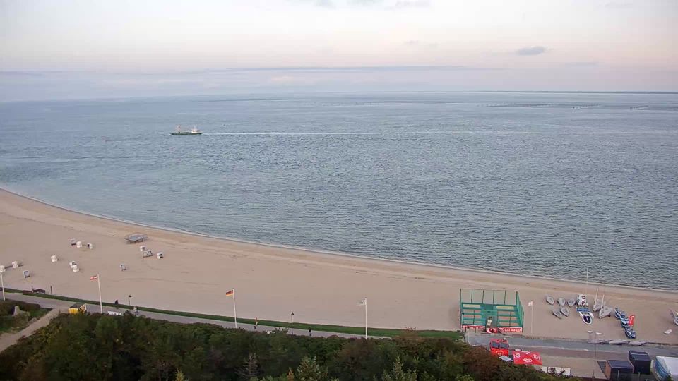
Webcam Rantum (Sylt) in diretta, previsioni surf e temperatura dell'acqua
Aggiornato 4 nov, 12:00 UTC
Condizioni attuali
In questo momento a Rantum (Sylt): 9 nodi da NE, raffiche a 15, onde di 0.3 m, acqua a 12 °C — onde piccole, buone per iniziare.
Previsioni a 7 giorni
| mer 4 | gio 5 | ven 6 | sab 7 | |||||||||||||||||||||
|---|---|---|---|---|---|---|---|---|---|---|---|---|---|---|---|---|---|---|---|---|---|---|---|---|
| 03 | 06 | 09 | 12 | 15 | 18 | 21 | 00 | 03 | 06 | 09 | 12 | 15 | 18 | 21 | 00 | 03 | 06 | 09 | 12 | 15 | 18 | 21 | 00 | |
| Vento | 10 | 9 | 8 | 9 | 10 | 11 | 10 | 9 | 9 | 9 | 8 | 8 | 8 | 11 | 11 | 11 | 11 | 12 | 14 | 13 | 13 | 14 | 13 | 11 |
| Raffiche | 15 | 12 | 12 | 13 | 15 | 18 | 14 | 12 | 14 | 13 | 12 | 12 | 11 | 16 | 16 | 15 | 16 | 18 | 20 | 19 | 18 | 20 | 18 | 16 |
| Direzione | ↑ | ↑ | ↑ | ↑ | ↑ | ↑ | ↑ | ↑ | ↑ | ↑ | ↑ | ↑ | ↑ | ↑ | ↑ | ↑ | ↑ | ↑ | ↑ | ↑ | ↑ | ↑ | ↑ | ↑ |
| Onde | 0.4 | 0.3 | 0.3 | 0.3 | 0.3 | 0.4 | 0.4 | 0.3 | 0.3 | 0.3 | 0.3 | 0.3 | 0.3 | 0.3 | 0.4 | 0.4 | 0.4 | 0.5 | 0.5 | 0.5 | 0.5 | 0.5 | 0.5 | 0.4 |
| Temperatura | 8 | 7 | 7 | 8 | 9 | 9 | 9 | 9 | 8 | 7 | 7 | 7 | 9 | 9 | 8 | 8 | 7 | 7 | 7 | 8 | 9 | 9 | 9 | 8 |
| Pioggia (mm) | ||||||||||||||||||||||||
Orari in ora locale · Vento, onde e temperatura dell'acqua: dati aperti ECMWF (CC BY 4.0) · Maree: EOT20, DGFI-TUM (CC BY 4.0)
🔒 I giorni 4–7 sono Pro — Il piano gratuito mostra i primi 3 giorni di previsioni. Passa a Pro per vedere tutta la settimana.
🔓 Pro — 19 € / anno
Le previsioni complete a 7 giorni su ogni spot, un abbonamento annuale a prezzo fisso.
Passa a ProPrevisioni surf
| mer 4 | gio 5 | ven 6 | ||||||||||||||||||
|---|---|---|---|---|---|---|---|---|---|---|---|---|---|---|---|---|---|---|---|---|
| 13 | 16 | 19 | 22 | 01 | 04 | 07 | 10 | 13 | 16 | 19 | 22 | 01 | 04 | 07 | 10 | 13 | 16 | 19 | 22 | |
| Surf (stima) | 0.3 | 0.3 | 0.3 | 0.2 | 0.2 | 0.2 | 0.2 | 0.2 | 0.4 | 0.5 | 0.5 | 0.5 | 0.5 | 0.5 | 0.5 | 0.4 | 0.4 | 0.4 | 0.4 | 0.3 |
| Swell principale | 0.25s↑ | 0.25s↑ | 0.25s↑ | 0.15s↑ | 0.15s↑ | 0.14s↑ | 0.14s↑ | 0.16s↑ | 0.26s↑ | 0.36s↑ | 0.36s↑ | 0.36s↑ | 0.36s↑ | 0.36s↑ | 0.36s↑ | 0.36s↑ | 0.36s↑ | 0.26s↑ | 0.26s↑ | 0.26s↑ |
| Swell secondario | 0.117s↑ | 0.116s↑ | 0.116s↑ | 0.115s↑ | 0.115s↑ | 0.115s↑ | 0.115s↑ | 0.15s↑ | 0.115s↑ | 0.113s↑ | 0.114s↑ | 0.114s↑ | 0.113s↑ | 0.113s↑ | 0.112s↑ | 0.112s↑ | 0.112s↑ | 0.17s↑ | 0.111s↑ | 0.111s↑ |
| Mare da vento | 0.22s↑ | 0.22s↑ | 0.32s↑ | 0.22s↑ | 0.12s↑ | 0.12s↑ | 0.12s↑ | 0.12s↑ | 0.13s↑ | 0.13s↑ | 0.13s↑ | 0.11s↑ | 0.12s↑ | 0.22s↑ | 0.22s↑ | 0.32s↑ | 0.32s↑ | 0.22s↑ | 0.33s↑ | 0.33s↑ |
| Onde | 0.3 | 0.3 | 0.4 | 0.3 | 0.3 | 0.3 | 0.3 | 0.3 | 0.3 | 0.3 | 0.3 | 0.4 | 0.4 | 0.4 | 0.5 | 0.5 | 0.5 | 0.5 | 0.6 | 0.5 |
| Periodo | 3s | 2s | 3s | 3s | 3s | 2s | 2s | 3s | 6s | 5s | 5s | 5s | 4s | 3s | 3s | 3s | 3s | 3s | 3s | 3s |
| Energia | 0 | 0 | 0 | 0 | 0 | 0 | 0 | 0 | 0 | 0 | 0 | 0 | 0 | 0 | 0 | 0 | 0 | 0 | 0 | 0 |
| Onda lunga | 0.0 | 0.0 | 0.1 | 0.1 | 0.1 | 0.1 | 0.1 | 0.1 | 0.1 | 0.1 | 0.1 | 0.1 | 0.1 | 0.1 | 0.1 | 0.1 | 0.1 | 0.1 | 0.1 | 0.0 |
L'altezza del surf è stimata dallo swell principale per una spiaggia rivolta verso di esso; reef, banchi di sabbia e marea la cambiano. Energia in kW per metro di costa. Onda lunga: onde da 12 s in su. Swell: NOAA WAVEWATCH III · ECMWF
Maree (prossime 48 h)
Info sullo spot
- Località: Rantum, Sylt
- Acqua: Mare
- Sport: SurfWindsurf
- Direzioni del vento migliori: EESESE
Rantum lies at the narrowest point of Sylt, where the island shrinks to a strip of dunes only a few hundred metres wide between the open North Sea and the Wadden Sea. The live beach webcam looks over the western beach, a long, straight run of fine sand with no piers or groynes in the way, facing the prevailing westerly wind and swell. That exposure makes it a surf beach: easterly winds blow offshore and smooth the waves, while a west or south-west wind brings choppy, powerful conditions that suit experienced windsurfers better than beginners. Rip currents form between the sandbanks, so swimming is safest at the guarded beach access in the summer season. Behind the village lies the Rantum basin, a diked tidal basin that is now a bird reserve, and on the eastern side the calm Wadden shore offers a completely different, flat-water view. The village is small, with holiday homes, a few restaurants and a bus link to Westerland and Hörnum. Sea temperature follows the North Sea pattern, cold until early summer and warmest in August. Watch the Rantum beach webcam and the surf forecast below to judge the swell.
Rantum (Sylt): domande frequenti
- C'è una webcam a Rantum (Sylt)?
- Sì. La webcam in diretta di Rantum (Sylt) è in cima a questa pagina, accanto alle previsioni di vento e onde.
- Con quale direzione del vento funziona Rantum (Sylt)?
- Funziona meglio con vento da E, ESE, SE.